
The geospatial data analytics company Mapcite, with whom I partner, are making an open offer to world governments to immediately provide their platform and services at no charge. Mapcite presents this compelling value proposition as a free community service, summarised as follows.
Governments need to be informed on the following attributes associated with COVID-19.
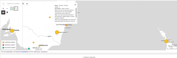
- Who has become infected?
- Who is at most serious risk?
- Are people adhering to isolation policies?
- Are isolation policies working in arresting the infection rates?
- Who has recovered?
- Where are extra medical products and services required?
- Are extra medical services improving the recovery rates?
- How do we manage vaccination programs when available?
- What will happen next?
Mapcite are offering to process and visualise multiple data sets to determine and target the high-risk communities together with those areas of likely low infection impacts. Mapcite already has many data sets but the ones that come readily to mind include:
- Age demographics
- Health demographics eg heart disease, obesity, diabetes, lung disease
- Hospital locations and facilities
- Population densities
- Transport routes and hubs
These can then be extended to data sets to address:
- Traffic flows on every street (which would indicate the effectiveness of isolation policy compliance against benchmarks prior to COVID-19). How this works together with geofencing can be seen at:
- Similarly for people movement data around cities and the states
- Existing infections locations (if available at a granular level), and recovery locations
With all the above information, Mapcite can monitor the isolation requirements under COVID-19 in an innovative and comprehensive manner. Mapcite can readily visualise where governments need to focus information awareness programs, track COVID-19 infections, monitor social distancing, deploy extra medical devices and/or services eg respirators (which are in very short supply relative to likely infected numbers), and in due course, manage vaccination rollouts.
The capability, including the Mapcite app, is mature and relatively easy to deploy and configure eg required geofences. All this can be done in days rather than weeks and we know that speed is key to controlling COVID-19 impacts on the community. The tracking used is anonymous using only device ids, thereby addressing privacy concerns. Please be aware that Mapcite’s experience has shown that most people are willing to opt-in for health and community benefit purposes especially given this anonymity.
Mapcite has previously assisted the National Health Service in the UK in processing vast amounts of prescription data to uncover insights into health challenges. During that process, the Mapcite platform was distinguished by its speed and volume of geospatial data processing, put in the hands and control of business users.
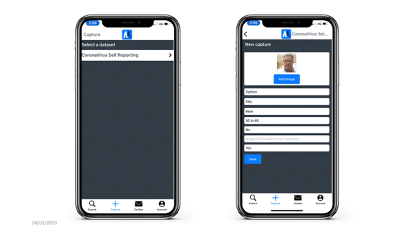
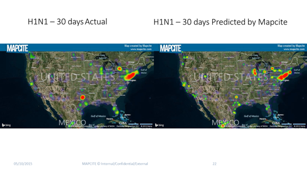
The other capability offered by Mapcite is Predictive Modelling. Previous work in this area by Mapcite was for H1N1 in the USA in 2015 thereby being very relevant for COVID-19. However, it must be noted that despite the capability using advanced AI including semantic processing and unsupervised deep learning, the results are only as good as the historical data entered into the platform. That’s where the government’s current collecting of COVID-19 data comes into play. In that regard, the Mapcite app has capability for user-generated data capture such as self-reporting, automatically noting the geolocation.
The available data for COVID-19 infections, deaths, and recoveries, can then be harmonised with the high-risk data Mapcite currently have such as age and health demographics eg elderly, heart disease, obesity, diabetes, lung disease. The predictive modelling will then show predicted priority areas requiring early and/or differential intervention.
Overall, the concept of “where” is so important in this challenge and this plays directly to Mapcite’s history, core capability, and expertise. I hope governments take advantage of all technology available to them in order to best manage this new world under COVID-19.
Author: Stephen Walker, GM Centre of Excellence for Geospatial in Australia